Ladakh is now saperated from Jammu and Kashmir and made a region administrate by India as Union territory. Ladakh border touches Tibet in east , at west Jammu and Kashmir and Gilgit Baltistan and at south it touches Himachal Pradesh. After made different state Government of India encourage Tourism in Ladakh. Leh is the largest town in Ladakh. Leh district contains Nubra, Indus and Shyok river valleys. Population in region are 46 % Muslims, 12 % Hindus , 40 % Buddhist and 2 % other religions. The culture in Ladakh is mostly related to Tibet. On 31st oct 2019 Ladakh is established as a Union Territory.
Ladakh Famous For :
Ladakh is famous for breathtaking landscapes, the highest mountain pass, advanture activities, Crystal clear sky and Buddhist monasteries.
Leh Ladakh Tour Package : Leh Ladakh Trip cost
Well Leh Ladakh Tour package depend on your budget. If you need to pay more at Hotels then your package will go around 40 K-50 K per person without flight. And if you comfortable with stay in tents then your tour cost reduce almost half around 22 K – 27 K per person without flight. If you go by car or bike from delhi then the Leh Ladakh tour cost around 40k -50k approx. Also you can visit Ladakh tourism for more details
For Leh Ladakh tour you have many options to go via flight and via road.
Delhi to Leh in flight Delhi to Shrinagar in Flight and then visit Kargil and then go to Leh . Via Shrinagar route your trip increase for 2 days for visit Kargil and Shri nagar. Do an adventure go via Manali to Leh on Bike or Car. That may increase your trip days around 15 days for round trip.Most people choose direct flight to Leh for Leh Ladakh trip. And most nature lover people choose Bike ride from Manali. Now a days Shri nagar route is also more popular too. The Best option for Leh Ladakh Trip is via bike or car from Manali because from here you acclimatize your body from cold waves gradually. Reaching Leh or Shrinagar direct via flight may be discomfort for body to acclimatize too early. So reaching direct Leh you must have to stay Leh for one day to acclimatize body in cold and low oxygen.
How Many Days you need for Leh Ladakh Trip :
Total 7 days enough for Leh Ladakh Trip when you go via flight at Leh.
Challenges face during Ladakh Trip :
Ladakh all places are above 11000 ft so you will face challenge of low oxygen. In leh oxygen level of normal body remains 85-95 . At khardungla pass and changla pass oxygen level at 70 for normal people. At these passes you must not stay more than 10 minutes otherwise you will face low oxygen and face headache, vomiting and breathing problems specially for kids below 5 -7 years and smokers. Other minor challenges like landslide is rare. Also main problem of washrooms there are no washrooms or restrooms excepts some dhabas and hotels in road from leh to pangong lake and nubra alley. Everyday travel 100 km approx is bit tough at this height. Road condition is good as managed by BRO. In Pangong Lake too much wind blow at evening so reach before 2-3 pm otherwise you can not stay at 5 pm on pangong lake . ( too cold and windy ).
Best Time To visit Leh Ladakh :
Well Leh Ladakh opens in April so its April to July is the best time to visit Leh Ladakh. After August there is too much snow fall and also too much cold so it is very difficult to stay at Ladakh in Winter. During April to July Leh Ladakh temperature remains 15- 30 degree. During night it goes down up to 5 degree. In winter temperature goes up to -40 degree or more in Dras sector. It is one of the coldest place in the world.
Places to visit in Leh Ladakh : Most favorite places in Leh Ladakh
Santi Stupa Leh Leh Palace in Leh city Hall of Fame Leh Sangam – confluence of Indus river and Zanskar river Magnetic Hill , Pathar Sahib Gurudwara Nubra Valley – Camel safari, Diskit Monastery, Lachung Temple, Turtuk , Ind-pak border Khardungla Pass Pangong Lake Changla Pass Druk white lotus school – 3 idiots rancho’s school Leh city shopping Tso Morii LakeLeh Ladakh Tour Itinerary :
DAY 01: ARRIVE LEH
Arrival Leh by flight and transfer to the hotel. After welcome drink (it’s a local energetic drink )take a complete rest for acclimatization to the height altitude of Leh (3500 meters). Have Dinner and overnight in hotel.
DAY 02: LEH to SHAM VALLEY REGION (90 KMS / 05 – 06 HRS)
Sham Valley
Hall of Fame (Museum Constructed by Indian Army) must visit for each Indian. At Hall of Fame you will be brief for Kargil War how our Indian Army capture the points at LOC.
Patthar Sahib at around 22 Kms from Leh was built in memory of Guru Nanak Dev ji Nestled deep in the Himalayas. A drive of 4 -5 km to Magnetic Hill which opposes the law of gravity. As you drive forward from Magnetic Hills, not long before Nimmu Village, there comes a Confluence of Two Rivers Indus River coming from Tibet (left) and Zanskar River coming from Zanskar Valley (right). Here river rafting also you can do.
Zanskar River is known for its popular Chadar Trek. Later we drive back to Leh.
Visit to Leh Palace at evening, Shanti Stupa & Leh Market.
stay at the Hotel in LEH. We stay at City Palace hotel in Leh. Good hotel near to the market.
DAY 03: LEH to NUBRA VALLEY VIA KHARDUNG LA 18,390 FT. (120 KMS / 4 – 5 HRS)
At early morning we drive to Nubra Valley. The journey from Leh to Nubra Valley passes over KhardungLa (The Highest Motorable Road In The World) at 5,602 Mtrs / 18,390 Ft, around 39 km from Leh. From the pass, one can see all the way south over the Indus valley to see Zanskar range, and north to the Saser massif. At Khardungla Pass you can stay only for 10-20 minutes because of low oxygen. Do not stay more than 15 minutes otherwise you will face mountain sickness or altitude sickness problems. Also carry oxygen cylinders in your car for any emergency. Oxygen cylinders are chargeable for everyone its not include in package. When we pass through Khardungla Pass and we check our oxygen level by pulse oximeter it shows around 60-70 so after that you will face headache, omitting problems if you stay more.
Nubra Valley is popularly known as Ldumra or the valley of flowers. It is situated in the north of Ladakh between the Karakoram and Ladakh ranges of the Himalayas. The altitude of the valley is 10,000 Ft. approx. After reach at Nubra we check in at our Camp / Hotel in Hunder for Overnight stay. In the evening you can walk around the villages to see how the locals live in this part of the world or go to desert for camel riding , ATV bike ride etc. Stay at the Camp or Hotel. We stayed at Nubra Escape Camp. Tents are neat and clean and well managed. Also Night sky looks great and I had capture Milky Way at night.
DAY 04: NUBRA Valley TO TURTUK Village (82 KMS – 3 HRS ONE WAY)
At early morning we drive to Turtuk, and a lot of other small villages, were brought under Indian control after the 1971 war, when the Indian army pushed the Pakistani soldiers past the mountains towering the Nubra Valley. Turtuk lies at the extreme corner of the Indian border, and hence its accessibility is a challenge. Due to treacherous roads and sensitive army base camps, permits were not issued to Indian civilians until late 2010. Now a days you need permit of Indian Army you need to pass through check post of Indian army where you show your identity and also car papers deposit for security perpose and you need to show them in return and collect them. Throughout the journey, one has the company of Shyok, as well as the vistas, that define the barrenness which is characteristic to Ladakh. From Turtuk village some distance there is a small village you can see the border of India and Pakistan and also no mans land between India and Pakistan. After visiting we drive back to our camp or Hotel in Hunder for Overnight stay.Stay at NUBRA VALLEY
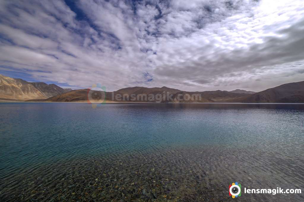
DAY 05: NUBRA VALLEY TO PANGONG LAKE (150 KMS / 5 HRS)
After breakfast we drive towards Hunder where you have opportunity to ride on a bacterian camel (double humped) amidst the sand dunes of this high-altitude desert with snowcapped mountains on the horizon. On the return stop at Diskit which is the headquarter town of Nubra Valley. Stroll around the bazaar observing the shops and local people going about their daily chores. Later we drive towards Pangong Tso via Agham & Shyok Valley. Some of the road patches in areas are extremely tough (towards nubra side) in terms of road conditions but no doubt the journey is very scenic! Later after crossing this adventurous part we drive further towards Durbuk & Tangtse for Pangong you pass through few small villages of Changthang and finally you can have a sudden view of the Pangong lake situated at 14,000 feet (4,267 m). Upon arrival we check in at our Camp/Hotel Near Pangong lake.
We stay at 100 sky camp at Pangong Lake. There are only tents available in Pangong lake and wooden cottage. At night and late evening weather is windy and cold. Wind blows high and temperature goes down. At night its very cold so prepare warm clothes and thermal. For children you need to be well prepared to protect from cold and low oxygen.
DAY 06: PANGONG LAKE TO LEH VIA CHANGLA (140 KMS / 6 HRS)
In the Morning explore the beauty of lake and later we drive back to Leh via Changla Pass 5486 Mtrs en route visiting Hemis Gompa, the largest monastic foundation of Drukpa Kagyu Order of Tibetan Buddhism. And futher to Thiksey an impressive complex rising tier upon tier on a hill above the village and another 5 Kms driving through a picturesque landscape we reach to Shey Palace, The ancient capital of Ladakh & 3 Idiots Rancho School. Drive to Hotel in Leh.
DAY 07: DEPART LEH (FLY OUT)
After breakfast we leave for Airport and back to our destination.
In above itinerary you can do Pangong Lake first and then go to Nubra Valley or do the same as itinerary.
In Leh city for south Indian food visit The Test of South India restaurant in market. And if you like to test famous food of Ladakh ( Thukpa )visit The Tibetan Kitchen.
What to buy from Leh Ladakh:
The best food serves here. For shopping you can take warm cloths , showls, warm jackets , hand glowes, local hand made items,carpets, handicrafts are cheap and good quality. Showls are bit expensive of Pashmina showl.
Apricot items are best to buy from here. Also dry fruits and apricot oil , lip balms are variety of Leh Ladakh is very good in quality and price too.
Things to Carry during Leh Ladakh Trip
Clothes as per your need ,take Full sleeve t shirts, pairs of woolen shocks, Bagpack for day travel, Water bottle, Good quality Shoes, Woolen Jacket which use in Extreme cold condition, Thermal, MonkeyCap, Goggles, Hand Gloves, Sun Cap, Cold Cream, Vicks, Band Aid, Medicines ( Diamox tab, Paracitamol, Electral Powder, ORS ), 4-5 Big polythene, Money, Original Photo ID, Camera kit , Take extra jacket for extreme cold condition in Pangong lake.
Diamox Tablet taken before 48 hours when you reach at Leh via flight. It is not necessary to take Diamox tablet before you fly to Leh direct. If you are physically fit then no need to take it. Just drink water at regular interval and hydrate your body. Take proper food and proper rest too.
What to do to avoid Mountain seekness:
If you feel headech or vomitting , lack of food and water then you are facing mountain seekness. You must need to hydrate your body everytime. Whenever you go directly at high altitude stay for 1 day to aclemite your body with weather. Then drink water , juice, local energy drinks , eat dry fruits, fruits , chocolates etc. Drink water more to hydrate your body then you will not face mountain seekness. After all if you feel seekness use ORS liquid and drink it. Take diamox tablet before 48 hours of flying high altitude. Take long breath regularly in 15 minutes. And if your oxygen level is below 60-70 then visit nearest hospital or go to down altitude station then you will feel better. And one must thing is do not drink during Leh ladakh trip. Drinking alcohol is not advisable in Leh ladakh trip.
Photos taken with Canon 6D with 14 mm canon lens
Read more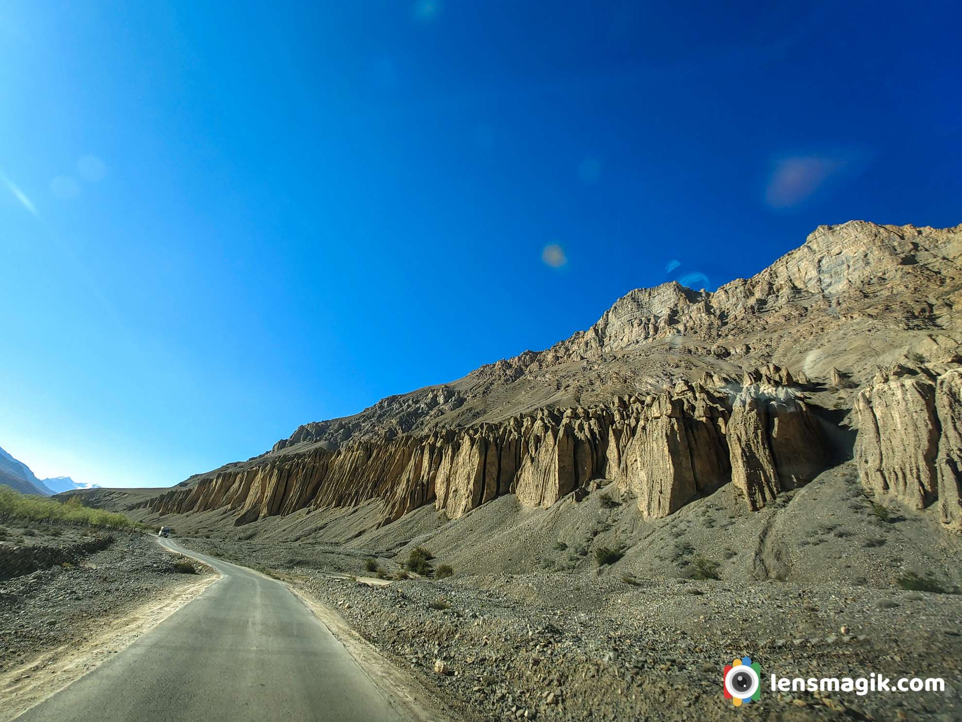
Spiti Valley located in Himachal Pradesh. It is a cold desert mountain valley of Himalayas. Spiti distributed in 2 parts Lahaul and Spiti. As per my last post of Spiti Valley Tour Itinerary there are lots of places to visit during spiti valley tour. It depends how many days you want to spend in spiti valley tour so you can much more places to cover in spiti valley. But i think 7 days are enough for Spiti valley tour to cover all major attractions. Most of time you spend in car during spiti valley tour. But definately the route is memorable for all. The view of Himalayas and the scenery is beautiful. Most people take 7 days tour from Chandigarh or from Delhi.
Best Places to Visit in Spiti Valley :
Chitkul Nako Tabo Dhankar lake Kaza Chandratal LakeWell in Spiti Valley Trip there are lots of places to visit but i will suggest you some of them to make shorter your trip. Also most attractions and must visit places i share here. If you want to spend more time then you can visit local village and enjoy village life too. If you want to know about Spiti Valley Tour Cost and Spiti Valley Tour Itinerary then i had written a post of it.
Honey Bee Farming :
From Chandigarh to Spiti you will have to pass Kinnaur District. It is very beautiful route with amazing greenery and scenery. During the route of Kinnaur valley there are lots of people do Honey Bee Farming on road. you can see the boxes of honeybee on roadside. They have different types of Honeybee and have different honey if you want to purchase pure Honey for home. They also saw you how they farming and do all procedure of making Honey.
Chitkul :
Actually we skip Chitkul because its out of our route and spend one more day. But Chitkul is must visit place. It is really beautiful place in the valley of Himalayas. Also Chitkul is known as India's Last village at Indo - Tibet Border. Border is about 90 km from Chitkul. Also civillian movement beyond Chitkul is prohibited. Best time to visit Chitkul is March to June. Also have a cup of tea at Hindustan Ka Akhri Dhaba at Chitkul. They also serve food with Rajma Chaval and roti.
Kalpa Or Rekong Peo :
If you visit chitkul and stay their then kalpa or Rekong Peo you can skip. Or if you do not visit chitkul then stay at Rekong Peo. Good to stay here very neat and clean hotels and also food is good here. Next morning you can see amazing sunrise in between of Himalayan mountains coverd with snow. Stay here for a night and leave next morning or you can visit local village and bazar.
Nako : Places to visit Nako
Nako village located near Indo-China Border. In Nako you can visit Nako Lake and Nako Monastery. Also you can visit some Buddhist chortens. Nako Monastery is must visit place with beautiful atmosphear at height. The Monastery founded in 11 th sanctuary .Monastery location is amazing where you can see 360 degree view of Himalayan Mountains. Spend some time at Monastery and go for Gue Mummy Stupa in the way to Tabo.
Gue is a village where 500 years old mummy preserved of Sangha Tenzing. Sangha Tenzing was Buddhist monk from Tibet. At stupa the mummy found in sitting position with his skin and hair intact. The road to Gue Mummy is out of Tabo route so you can take extra 1-2 hours time while leave from nako. At evening you reach at Tabo village.
Tabo : Places to visit Tabo
Tabo is a small village on bank of Spiti river in spiti District. Tabo is famous for operated continuously oldest buddhist enclave in Himalaya and India. Most famous attraction of Tabo is Old Tabo Monastery which is 1000 years old and also considered as one of the holiest by Dalai Lama himself. Also another monastery in Tabo in the center of village you can visit. Tabo caves you can visit while visit monastery and if you stay for day more then you can go at river bank to feel nature. That was amazing view of spiti river near to the village and other side the big mountain.
Dhankar Lake and Dhankar Village : Places to visit Dhankar
From tabo to kaza route you can visit Dhankar Village. In the village there is a capital of spiti valley in Himachal Pradesh. It is at 3894 mt height. Here you can visit local village , Monastery and if you want to go for trek about 3 km then go to the Dhankar Lake. Dhankar village total houses are around 65-70 and population around 250-300 .
Dhankar Lake :
Dhankar lake is high altitude lake in himachal pradesh. It is located around 4140 mt height. From monastery you can go to Dhankar lake by trek about 3 km and it will take around 1-2 hours depends on your mountain skills. Trek route is very easy but its at more than 13500 ft height so high wind blows and low oxygen level make your trek difficult. Also here UV index is high so do not go in open skin or use sunscreen lotion. High UV index may damage your skin. At the end of trek you can see a beautiful green color based lake surrounded by mountains and open land. The view of lake is awesome and you can spend more time to make a peace to you mind. Crystel clear water in the lake. We take some photos and get back to village and drink lemon soda from local villager to get energy. Local peoples are so supportive and good nature.
Kaza :
In Kaza there are several places to visit so you visit all in a full day. Also kaza atmosphear is very cold in summer also so enjoy it.
Places to Visit In Kaza
Sakya Tangyud Monastery : It is one of the highest altitude Monastery in India. It is at 4550 mt height. It is at komik village. Kaza Kye Monastery : Kye or Kyi monastery is a tibetian buddhist monastery. It is set on top of the hill and its height aroun 4166 mt. It is the largest monastery of Spiti Valley. Langza : Langza village is also known as Fossils village. It is believed that spiti was submerged under the tethys sea so that huge quantities of fossils found here. In Langza there is a 1000 years old Buddha Statue is major attraction. The Buddha statue at Langza located at 14500 ft height. It is serene golden large Buddha Statue. From the Buddha statue at Langza you can see 360 degree view of Himalayas.Hikkim : Hikkim is located at 14400 ft height in lahaul spiti district. Hikkim village remains cut off during winter due to heavy snow fall over mountain passes. The Hikkim village has a post office at 14400 ft height. So it is also on of the highest post office in the world. Kibber Village : Kibber is famous for Monastery, kibber wildlife sanctuary, the highest post office and the highest motorable road. Kibber is located 19 km from kaza. Kibber is also famous for Snow Leopard. There are almost 25-30 snow leopards In Kibber Wildlife Sanctuary. Komic : Komic is also one of the highest village in the world located at 15050 ft. It is also connected with World's Highest Motorable Road. So it is known as Highest Motorable village in the world. There is a restaurant their named World highest restaurant Komic. You can take rest have a cup of coffe or tea and have some snake, meggy etc. Chicham Bridge : Chicham bridge is highest bridge of Asia. Bridge is located at 13596 ft height. The Chicham Bridge connect 2 village one is Chicham village and Kibber. The bridge is suspension bridge and is situated across a deep gorge around 1000 ft. Chicham Bridge is one of the spectecular bridge in the world.
Kumzum Pass : While return from Kaza to Manali you will pass through Kumzum Pass. It is one of the best route for enjoying nature very closely. The car speed is very slow due to bad road condition but at Kumzum pass we face fresh snow fall and fell zero degree temperature. Amazing view at Kumzum pass. Also Kumzum Mata Temple located at 4590 mt height. There is a myth about Kumzum mata temple you need to do a circle and after go through your journey to Chandratal Lake or Manali.
Chandra taal Lake : As per Hindu Mythology Chandra taal is the place where Lord Indra came down with Chariot to transport Yudhisthira in his mortal from to Swarga or Heaven. Also local believed that fairies visit lake at night. Chandratal Lake is open in summer after may end or June start. So if you want to visit Chandra taal lake then plan in June. Also there are limited option for staying at Chandra taal Lake.
Things to know about Spiti Valley Tour :
While you planning for spiti valley tour you did not need to book hotels or homestays. There are lots of homestays and hotels every where. You can also book your homestays and hotels via Spiti Tourism or Himachal Pradesh Tourism. They will help you a lot for entire trip. Local peoples are so supportive and kind nature. They will aslo help and guide you to your destination.
Which Mobile network works in Spiti Valley ?
Most people have a question about network connectivity at Spiti Valley. I will take 2 simcards for my Spiti Valley Tour one is Reliance Jio and one is BSNL prepaid. After kinnaur vally pass all major networks are down but BSNL and Reliance Jio is connected to everywhere in spiti. Reliance Jio has better network connectivity even in internet also. So i suggest take Reliance Jio sim card for your trip. Only it fall down during Kumzum pass route. Otherwise in Kaza, Tabo, Nako all places covered by Reliance Jio network.
Best time to Visit Spiti Valley :
Well the Chandigarh to Kaza route open all year but sometimes landsliding may occer and also some heavy snowfall then it will take 4-6 hours to clear road. Road managed by BRO ( Border Road Organisation ) . Plan during mid of may in spiti valley because there is low crowd in May. But in May there may be return route block via Kumzum Pass and Chandratal Lake. June is more better for Spiti Valley tour to visit all the places. Some bikers may visit spiti valley in December for adventure too.
Road Condition In Spiti Valley :
From Chandigarh to Kaza there is a clear road. At some places road condition is not good but main road is very impressive and no hazitation during the entire trip. Some village route is not good but it will manageable. The Kaza to Manali Via Kumzum pass road condition is not good so you need to travel whole day for Kaza to Manali.
Star Gazing At Spiti Valley : Spiti Valley Night Sky
Well spiti valley is dark area where you can do stargazing verywell. Here you can see milkyway clear during no moon days. For milky way Langza is the best place in Spiti Valley.
Spiti Valley Food Option : I will recommand The Himalayan Cafe in Spiti Valley for food. Well managed cafe and food options are amazing. Must visit place in Spiti valley.
You can visit my blog http://bit.ly/3zYFdVv about spiti valley tour itinerary and total cost with details. Also provide hotels and homestay options. You can write me if you need any help about spiti valley tour at nirajhack@gmail.com
Read more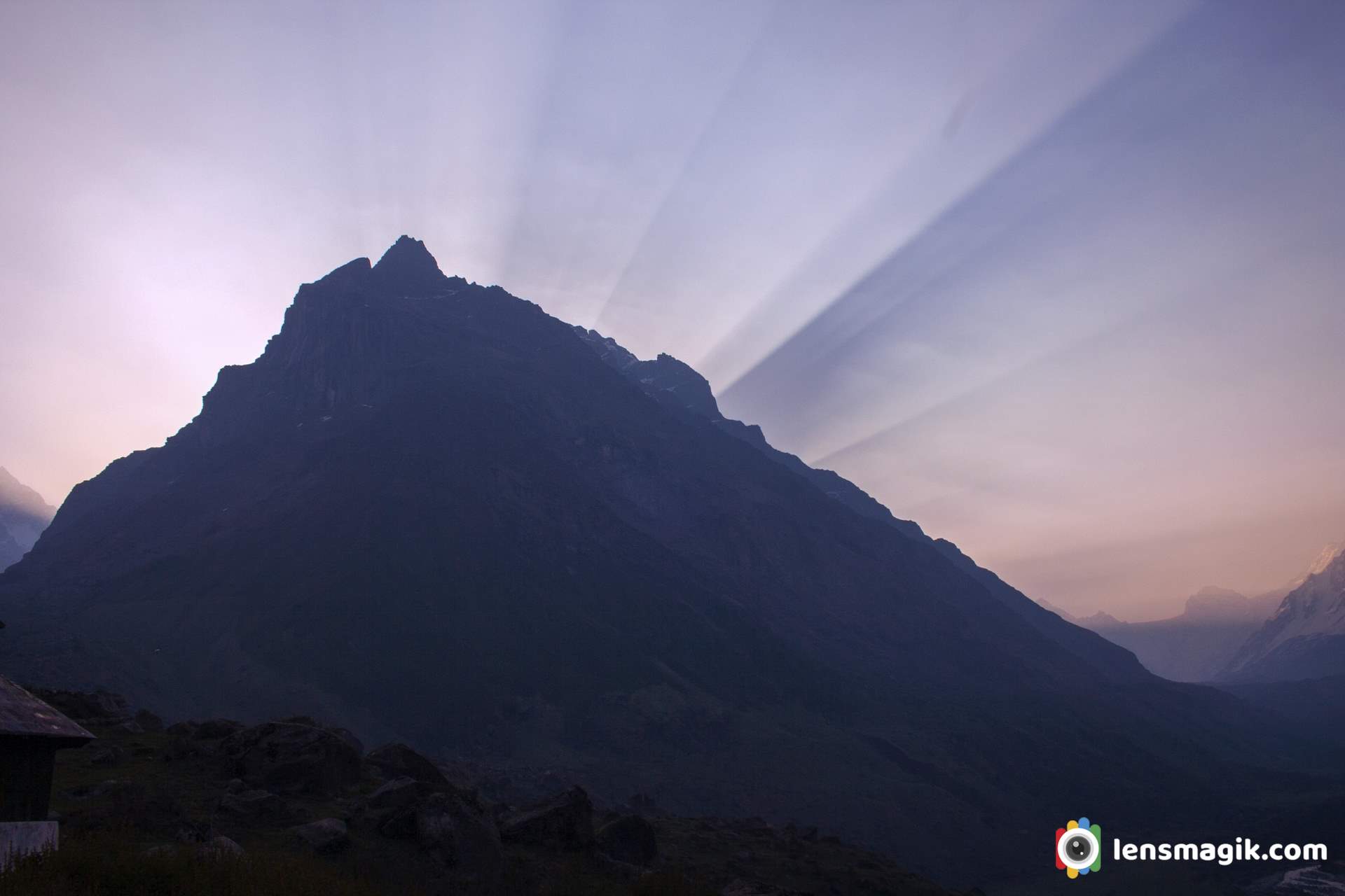
Har Ki Dun valley or Har Ki Doon valley whatever you say the valley is in Uttarakhand state. The har ki dun valley is in Garhwal Himalayas. The valley has beautiful scenic views of Himalayan Mountains. The har ki dun valley height is approx 3566 m up from sea level mean around 11700 ft. During winter October to march the valley fully covered with snow . So you can visit in both season to see different views of Har ki doon valley. In winter it looks full covered snow and in summer u can see snow mountains, dense green jungle, meadows, green patches with orchids etc. Har ki doon trek is moderate trek and it will start from sankri village. You can complete har ki doon trekking in five days from sankri - har ki doon-sankri. In winter trek will go harder because of snow.
Best Time for Har Ki Dun trek : Har Ki dun trek Best Time or Best season for har ki dun valley trek
Har ki dun trek can do in both season but i suggest do it in may to july in summers. Also beauty of winter season is also amazing but its very very cold in winter. In summer you can easily enjoy nature and walk through route. Also find beautiful birds during trek. Winter is challanging for this type of treks. Still some advanture lovers can do it in winter but they have proper guidence and good guide too.
Har ki Dun or Har ki Doon trek Package / Har ki Dun trek Cost :
Well i would suggest if you are going on trekking anywhere go with local guides. That is most cheaper your journey. Contact your trek local person with guide and porters which gives you a best price on your trip and also either or you support the locals. Local peoples has the only that income so you can directly help them . Most professional trekking tour operators book local guides. So ultimately you go with them only. My whole trek to Har ki Dun from Mehsana to Mehsana cost around 15k INR. With train and all . Now a days the price may increase. During trek to har ki dun it starts from sankri you have only homestay at sankri after that you will have to stay in tents only with sharing basis. Foods they serve at their best . My total Har ki Doon Itinerary you can see on my different post.
Har ki Dun Valley of Gods :
Har Ki Dun is also known as Valley of Gods. The local peoples says about the story that The PANDAVA'S goes in heaven through this way. And the Mountain where Pandavas go to heaven is called " SWARGAROHINI " . This peak is un- climbed till now as I know. The view of Swargarohini is really looks like heaven. On the way to Har Ki Dun you can continuously meet river named Rupin, Supin and Tons and after all its merge into Yamuna.
Is it Har Ki Dun or Har Ki Doon ?
Well you can say Har ki Dun or Har Ki Doon both are same in pronounce speaking. Also both are same place but spelling of Dun/ Doon are different. Most of says its Har Ki Dun valley and most say Har Ki Doon valley. Har ki Dun is a mountain of Lord Shiva as per local says. Mountain is untouch and not for climbing. Valley of Gods name because from here you can see a beautiful valley and at end of valley mountain " Swargarohini " where Pandava's Goes in heaven through this way. So this valley called Valley of GOD's.
Har ki Dun Trek : Har Ki Dun Trek Route
Har Ki Dun trek starting point is Sankri. Sankri is base camp of Har ki Dun trek and also for Kedarkantha trek. Also Ruinsara trek done from sankri base camp. So sankri village is best place for trekkers. From Sankri to seema and seema to Har Ki Dun trek of total 30-35 km approx. Its a moderate trek and you can do it easily just some few difficulties in between. Lots of Birds found here. So its good trek for birders too. For Har ki Dun trek Itinerary i write an article for full itinerary so you can follow that itinerary too if you want.
How Difficult Har ki Dun Trek Is ? : Har Ki Dun trek Dificulty Level (Moderate) :
Well Har ki Dun trek is moderate trek. If you can do easy treks about 5-8 km then you can do it . You can have some difficulties during trek when high step up at some places but not so difficult it. You can do this around 35 km trek in 2 days and also can do in 3 days as per your capacity.
Above images gives you some better idea for Swargarohini peak . Awesome scenery like a wallpaper. I like below image because there is everything in one frame which i want to capture ( Mountain with snow, Dense jungle, River, Sun rays , Dramatic sky ). That's why I love this photo much even it could better if professional photographer shoot it.
Amazing Himalayas :
Himalays is the best place for landscape lovers and also for trekkers. Lots of unexplore places where you can go in Himalays. Amazing beauty of Himalayan Mountains from above 10000 ft heights. Also easy to hard treks to be done at Himalayas. Amazing landscape photography you can do here at any place also you can do night photography , star gazing, star trails, longexposure photography and also a time laps photography which shows amazing beauty of Himalayas. Weather is variable but plesant during summers. During winter its too cold at some places.
Har Ki Dun Trek Panoramic Images :
The Valley of Gods the names tell everything about Har ki dun trek. Its really amazing view of Mountains, river, valley and also green layer of lands. The panoramic view of this trek is amazing and i capture it from my mobile at different location of trek.
Har ki Dun trek Mobile Photos :
I capture some good images from my mobile. Landscape photography at har ki dun trek is amazing and i also love to shoot landscapes most. We are looking for birds also in our route and get beautiful birds during our trek to har ki dun. We found good number of spices of birds during trek. Birds found in Himalayas are really challenging to capture because of dense forests. We found Birds at har ki dun around 15-20 spices actually i don not know actual number but more than it.
Gear used : Canon 6 D, Canon 100-400mm lens, Canon 50mm lens,Canon 1000 D, Canon 18-55 mm lens
Location : Har ki Dun , Har Ki Doon, Valley of Gods
Read more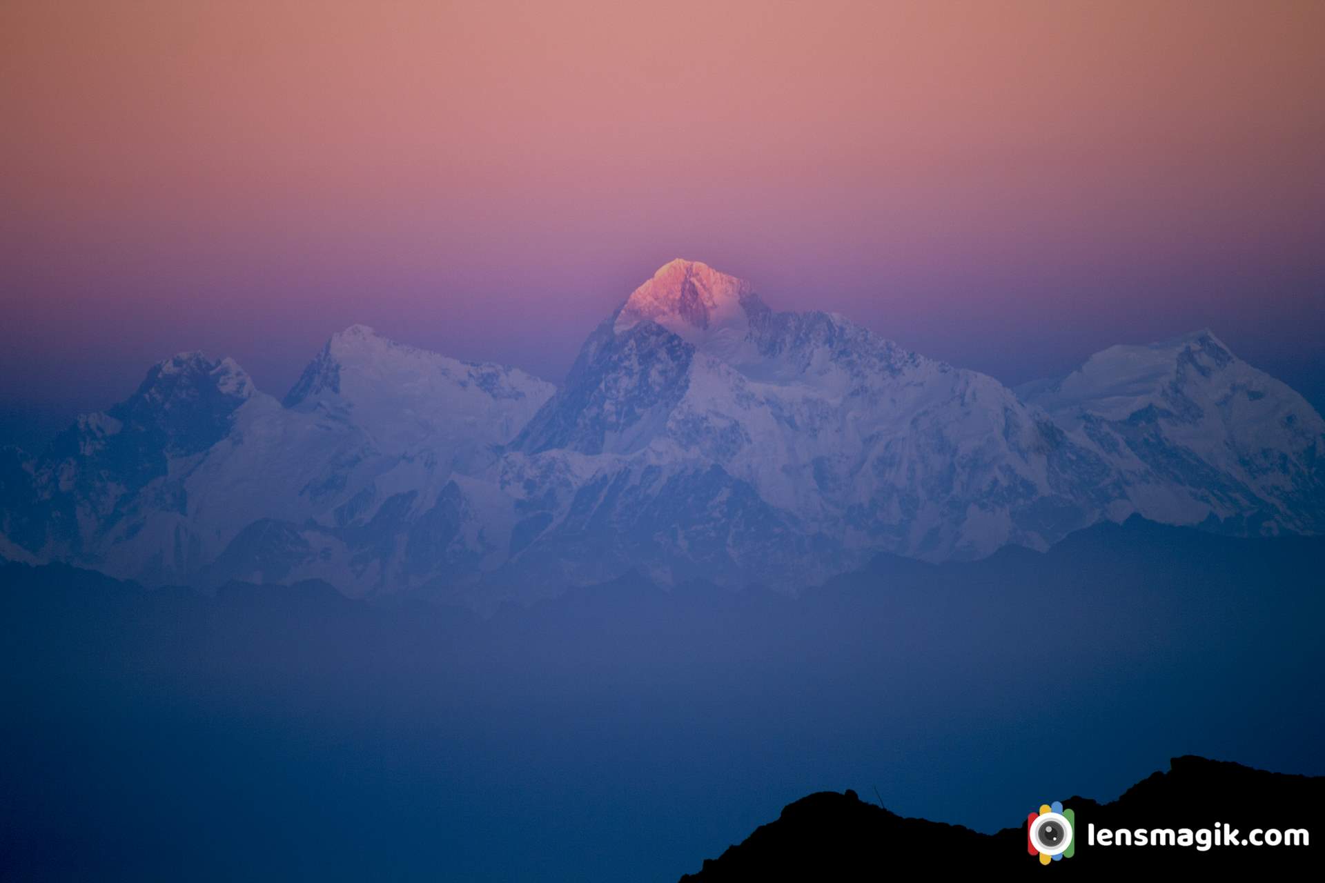
Singalila National Park is located in the Darjeeling district of West Bengal. It is at an altitude of almost 7000 ft. above sea level. I visit Singalila park on 6-12 Nov 2012 participating in Nature wanderers. It was a wonderful time to spend with the wild life photography experts Shivang Mehta(Delhi), Tejas soni(Gujarat) and Shantanu prasad(Kolkata). I joined first time in wild life photography tour and had a great experience. Geographic location of singalila national park is located in Singalila ridge. There are two rivers flowing through park. River Rammam and River Shirikhola. Sandakphu and Phalut are highest peak of west Bengal.
Trek To Sandakphu : Singalila National Park is a bird sanctuary cum wildlife sanctuary. A track route from Manebhanjan - Guiribus - Sandakphu covers Singalila park. Guiribus is a base of very rar Red Panda but we are not very lucky to catch them. Weather is awesome to guiribus.5 am sunrise u can see and at 3 pm u can see the clouds take charge as seen above picture. After 3-4 pm u cant get sunlight. Also a big problems at these places of lights. They have only solar lights. A trek to sandakphu is starts from manebhanjan. You can go by trek (by walk) or you can take a ride of Land Rover from 1960s. Rate for Land Rover is around 5000 INR for round trip from Manebhanjan to Sandakphu and extra 1000 INR for night halt per night. These price rates are in year 2012-2015 so now a days price are different.
About Sandakphu and Singalila National Park : Sandakphu is almost 11700 ft height. Such a great place it is as per location and weather. We stay at border of Nepal-India. At sandakphu you can see beautiful Himalayan Mountains Mt Kanchenjunga, Mt Everest, Kumbhkarna Mountain etc. At this height you may also find snow in winter season. Morning sunrise and evening sunset scenery are really beautiful with Himalayan range. Amazing view of Mt. Kanchenjunga the highest peak of west Bengal. You can get beautiful pictures of morning golden light on Mt. Kanchenjunga and other Himalayan mountains. Also the night scene is amazing. You can see amazing night sky which full of stars and milky way. You can see milky way easily from sandakphu. You can do stargazing from Sandakphu. I had done my first star trail at sandakphu.
Amazing landscape of Himalayan mountain range with clouds. The layers of mountain range with snow on last looking awesome. Singalila national park is really good for birding, trekking and Landscape photography. Here you can take good Landscape photos of himalayan range. Also Sandakphu is good place for birds too, Here you can also take good macro shots of morning frost in winter.
The land rover car of 60's ride to sandakphu from manebhanjan. It was joy ride in land rover.
Best Season To visit Sandakphu : Amazing weather in November. Extreme cold season. You stay beyond the clouds looks like you are in heaven. Every morning some snow frost on leaf of bush. Don't go their during rainy seasons. In rainy seasons leeches are come out and they are very dangerous for us. So not in a rainy season whenever u go their just prepare urself for every challenges. For birding you can go in Febuary to June.
Wildlife At Singalila National Park : Also sandakphu trek is beautiful for birding. Bird watchers may come in blooming season for birding. Singalila national park is beautiful place for bird watchers and wildlife photographers. Lots of birds like Himalayan vulture, scarlet minivet, khalij Pheasant, Blood pheasant, Parrotbills, Tits, Warblers, Finch, Fulvetta, owls etc and also mammals like Red Panda, Leopard cat, wild boar, Yellow throated marten, barking deer, Himalayan black bear, leopard, pangolin etc.
Above image i don't know what actually it was but i guess that it was Buddhist small God and one type of praying to Lord Buddha. It was made by white sand and made like lord Buddha's Idol.
Morning frost in above image show the beauty of Singalila National Park. Also birds makes more beautiful to Singalila National park. Some birds i capture here like Dove, Jungle Owl, warblers, Tits etc.
How to reach Sandakphu : By train you can go from Kolkata overnight train to New jalpaiguri and from their you can go by car around 4-5 hours to Manebhanjan. Or you can take a flight to Bagdogra Airport and from their go by car to Manebhanjan. After Manebhanjan its up to you to go by trek or go by Range Rover Car. Car rentle is around 5000 - 6000 INR per round trip and may night charges extra 1000 INR and park fees camera fees and others are extra.
At the end the full Panorama view of Sandakphu . Panorama of Singalila National Park. Panorama Mt. Kanchenjunga.
Read moreAccentor is a small bird of prunellidae family. In India it is generally found in East Sikkim area. It built its nest low in a bush. When i was on a trip to Singalila National Park. I found at sandakphu area. Sandakphu is high altitude place in Singalila National Park located in West Bengal. From here you can see Mt. Kanchenjunga very clear which is highest peak of West Bengal. Lots of Birds here. To visit Singalila Park November to February you can found lots of snow and good landscapes too with snow on Mt Kanchenjunga. Also if you are going for birding you can visit March to May/June Month is the best . It is very cold weather during winter November to February at Singalila National park.
About Alpine Accentor Bird :
Alpine Accentor bird is robin size bird. Length of bird is around 15 -17 cm. Bird just like similar to house sparrow in color with brown back streaked. Adult Alpine Accentor have red brown spotting on underparts Also adult have grey head too. In Asia Accentor found at 2000 m above height. Specially at Himalayas. It build nest in bush. It laying 3-4 plain (not spotted) eggs of sky blue color.Singalila National Park :
Singalila national park is located in West Bengal. There are lots of birds in this sanctuary. Also its good for trekking at Sandakphu. From here you can see Mt. Kanchenjunga easily and very closely. Also a beautiful Himalayan Mountain range with snow. Amazing weather very cold in winter and moderate in summer. Summer season is the best for birding at sandakphu.
Alpine Accentor bird Binominal Name is Prunella Collaris . Total 9 subspices are recognised of Alpine Accentor bird.
Gear used : Canon 1000 D, Canon 55-250 mm Lens.
Road To Heaven is named to the road from Khavda to Dholavira in Kutch Gujarat. The road is so wonderful and scenery so it known as Road to Heaven . Khavda to Dholavira distance is around 58km but from Khavda there is a single line narrow road passes through small villages around 15-20 km approx. The main road starts after it and it is around 30-35 km approx. strait to Dholavira. Road is under constriction but almost 70-80% work done. The road heading to the city of Harappan Civilization Dholavira which is one of the largest site of Harappan Civilization and Indus valley Civilization.
Kutch is a largest district of Gujarat and also of India. Main City or Headquarter of Kutch District is Bhuj. Kutch is famous for White Desert or White Rann. In Every winter season from December to February celebrate “ Rann Utsav “ to attract foreigners and also locals. Tent City made in white desert to stay and also cultural programs arranged in it. The main Rann Utsav held in Dhordo of Kutch.
After visit White desert people also visit Dholavira which is nearest destination from Dhordo and also Kalo Dungar in between. From Dhordo you will have to go Khavda first and then from Khavda to Dholavira which is connected through “ Road To Heaven “. Dholavira is located at Khadir Bet. Khadir bet is separated because after monsoon the water filled outer side of bet. So the Road To Heaven is the way to connect Khadir bet to main city Bhuj.
About Road To Heaven Dholavira / Road to Heaven in Kutch :
· It connected from Khavda to Dholavira.· Road to heaven distance around 30-35 km.· After monsoon the rain water on the both side of the road. You can see beautiful Greater Flamingo birds in between. Water level is low but muddy.· After winter in January –February the water on both side of the road is evaporated and turn into salt. Not all water but some areas during the road.· Water on the both side of the road or Salt/ white layer on both side of the road make the beauty of the road and that’s why it name as “ Road To Heaven “· When you are on the road there is hardly some traffic you face the open road with both side water or salt at morning or evening make the scenery like a Heaven.I must suggest to visit Road To Heaven in Kutch while you visit Kutch. Also Visit Dholavira which is one of the largest Harappan Civilization site.
Places to visit near Road To Heaven :
Dholavira, Kalo Dungar, Dhordo, White Desert
Places to Visit near Bhuj : White Desert , Kadiya dhro, Chhatardi, Mandvi beach, Vijay vilas palace, Bhujyo Dungar, Smriti Van, Vande matram memorial
Camera Used : Canon 80D, Canon 6D, DJI Mavic Air2
It is the largest species of Flamingo bird family and also a most widespread species of flamingo family.It is found in India ,south east , middle east and Africa. It is migratory bird. They also breed in India. In Gujarat they breed in Rann Of Kutch , Little Rann of Kutch also found in Thol Bird Sanctuary. I often visit Thol sanctuary so got good shots of them. Best time for shoot them is may-Jun at Thol bird sanctuary bcz of water level is too low . It is been recorded that some flamingo birds are resident in Gujarat at many places like LRK, Khijadia sanctuary, Nalsarovar and Thol Sanctuary. They also breed here and stay for all seasons. So you can find greater flamingo birds in all seasons in Gujarat at many places.
Flamingo bird facts and description :
Greater flamingo bird is the largest living spices of flamingo. Greater flamingo has no subspices. Flamingo color most of pinkish white in plumage. Wings are red and feathers are black in end. Greater Flamingo bird call is like honking. The average lifespan of flamingo bird is 30-40 years. Main Difference between Greater flamingo and lesser flamingo is height . Lesser flamingo is shorter than greater flamingo. Also Greater flamingo has pale pink bill and black tip. In other case lesser flamingo has dark crimson bill. Lesser flamingo is also more red in color than greater flamingos.Greater Flamingo birds In Thol Lake : Thol sanctuary is often i visit. Flamingo birds are stay here all seasons. I got good numbers of Greater flamingo and lesser flamingo bird images in a group when i visit Thol. This is my best time with flamingos. Also i got some beautiful pictures of flamingo birds with group and also in duo with some masti. Flamingos looks very good in frame bcz of their color. Thol lake is good place for birders because more than 150 birds spices found here. Also some mammals like Blue bull and black buck also found here. Lots of water birds and tree birds found here. Also sanctuary is not so big so you can find all birds in around 6 sqkm area. Best time to visit thol lake is November to March. All migratory birds are visit in winter so that is best time. Early morning is best for birders.
Timing And Fees of Thol Sanctuary :
Thol Sanctuary open at 6 AM in morning and close at around 5 PM
Fees of Thol Sanctuary is 50 INR per person and camera fees are 200 INR. Car fees are 500 INR.
Weekend fees may change that actually i don't know about it.
Two flamingos with little egret in between of them with down head all. The images of flamingo bird making a good frame. Because of its color flamingo birds images are very attractive and also their grouping make a perfect frame of flamingo bird picture.
A morning pared time for flamingo birds. A beautiful Greater flamingo birds are in a raw make image nice and show their unity.
Perfact wingspan of Flamingo bird looks great. Pink Wings make image more attractive.
Solo Greater flamingo bird
Some masti time for two flamingo birds .
Above image shows the discipline of Flamingo Bird and looks like a morning pared they are doing .
https://youtu.be/9dVBrR9NSOo
A group of Flamingo Birds at Thol Lake make your frame awesome.
Location : Thol Lake, Gujarat
Thol lake is just 25 km approx. from Ahmedabad. You can visit one day for Thol lake is enough. Also you can find another migratory birds like pelicans , bar headed goose, river tern and many more resident spices.
Ahmedabad to Thol lake distance about 25km
Thol bird sanctuary is located in Kadi Taluka in Mehsana District near sanand Gujarat. It is an artificial lake located near village Thol. In 1912 thol lake was built and it was declared as a Sanctuary in 1988. The main use of lake is use of water for irrigation. The Thol Bird Sanctuary or a Thol lake wildlife Sanctuary India is a habitat of more than 150 spices of birds. Also it is famous for migratory birds Flamingos and Sarus Crane which breeds here.
About Thol Lake / Thol Bird Sanctuary Thol lake is located near Thol village and its area around 38000 acres. Lake faces all season winter , summer and monsoon. During winter temperature goes to 8 degree and in summer temperature goes to 43 degree. Thol lake is under control of Forest and Irrigation department of Gujarat. Thol lake water storage capacity is around 84 million cubic meters. Thol wildlife sanctuary is declared as Eco Sensitive Zone .
Flora and Fauna Thol Sanctuary : Thol lake has many vegetation plants like Zizyphus, Acacia nilotica, Ficus, Capparis, Azadirachta indica etc. There are also some mix flora of Marshy and Aquatic plants reported in Thol Lake. Thol lake is protected area and it is very good habitat for water birds. In thol bird sanctuary there are more than 150 spices of birds found . Among these more than 60 % of birds are water birds. Flamingo bird is most prominent bird of Thol Lake. Also Sarus Crane nest in large number here.
Famous Migratory Birds of Thol Lake
• Flamingos • Sarus Crane • Great White Pelican • Mallards • Bar Headed Geese , Grey Headed Geese • Waterfowl
There are also some spices reported here like Dalmatian Pelican, Indian Skimmer, Greater Spotted Eagle, Indian Vulture and white rumped Vulture etc. In Mammals Bluebull, Blackbuck and Golden jackal reported here.
Thol Lake Timing and Fees : Thol lake open everyday at 6 AM in morning and close at 5.30 PM in evening. Entry fees for Thol Lake or Thol sanctuary is 50 INR for per person. Also Camera fees extra at 200 INR and if you go via car then car fees also 500 INR. Foreigner fees are 10 $ per person.
Best Time to Visit Thol Sanctuary / Thol Lake : Best time early morning for Thol Lake. In winter if you go before sunrise you can see Twilight sky amazing with lake shore and birds sound .During all season Thol lake has its own beauty. Every season you can visit at Thol Lake. But mostly during winter from November to March season is best for Thol Sanctuary visit. Because during winter lots of Migratory birds came here and stay for long time so for birding winter season is best at Thol Lake. Also during summer some of birds stays here like flamingos and pelicans, geese etc. So you can also see them in summer too. Also during summer water level of lake is low so may be the birds you can get in deep or sometimes closer. During monsoon most people don’t visit but if you like macro photography then you must visit Thol lake in monsoon. You can get some excellent macro subjects like waterdrops , Spiders, Insects etc.
What to do and What not to do in Thol Lake / Keep in mind while visiting sanctuary in India :
• Keep silence in sanctuary • Maintain discipline • Keep sanctuary clean • Do not throw plastic waste anywhere in sanctuary • Protect wildlife • Observe birds, mammals etc and protect them and identify them • Follow rules of wildlife protection act -1972 • Don’t disturb birds and animals • Don’t enter in sanctuary with liquor and inflammable objects • Don’t make loud noice. • Enter in sanctuary with permit only and keep receipt till you leave sanctuary • Don’t feed birds and animals
Where to Stay near Thol Lake : Well near to Thol Lake there are not good places to stay at night but you can go near to destinations like Kadi, Kalol or Gandhinagar , Ahmedabad where you can get good places to stay at night. Nearest I suggest Kalol around 15-18 km or you can go Ahmedabad around 25 km.
Places to Visit near Thol Lake : If you are staying at Ahmedabad then go for Ahmedabad Darshan , Pol area of Ahmedabad and Adalaj Ni Vav ( Heritage places ) etc. Also go for fast food test at night at Manek Chauk and SindhuBhavan road there are lots of option for food lovers like Urban Chauk, Freezbee etc.
If you stay at Gandhinagar then visit Mahatma Mandir at Gandhinagar, Sarita udyan , Akshardham Temple etc.
I would suggest Modhera Sun Temple if you had some more time which is around 100km from Ahmedabad. For bird lovers and bird photographer I would suggest visit Little ran of Kutch (LRK) during Winter season, Pariej Lake, Indroda park Gandhinagar, Jessore Sanctuary Banaskantha etc.
How to Reach Thol Sanctuary : Nearest airport is Ahmedabad and from Ahmedabad thol lake distance is around 30-40 km Also for Railway station is Ahmedabad because you can get all frequency and destinations from Ahmedabad railway station.
Mt Kanchenjunga or Mt Kangchenjunga both spellings right and whatever you say located in west Bengal India. When i was on my Singalila National park trek i visit it. It was really gesture to see Mt Kanchenjunga from own eyes. A beautiful Mountain surrounded by snow and little bit clouds looks like you are in Heaven. The view i capture makes me very happy to see first time snow mountain in my life. When i was at my last location of my trek at Sandakphu we go for birding and v had a clear mountain view of Kanchenjunga. Kanchenjunga is also spelled Kangchenjunga. Height of Mt. Kanchenjunga/Kangchenjunga is 8586 m . The view of Mt Kanchenjunga from India is amazing as you can see in photos. This Mountain range in wide angle as shown above image looks like Sleeping Budda so this mountain range also known as Sleeping Buddha Mountain Range too.
The name Kanchenjunga is derived from sanskrit kanchana ganga . Kanchana means gold and ganga is the river which flows in the region. The river shines like gold and hence the name Kanchana Ganga was given to this mountain.
Things to know About Mt. Kanchenjunga/ Mt. Kangchenjunga :
Kanchenjunga Mountain is about 28,169 ft height and located along the Nepal-India border in the Himalayas. It is the third highest mountain in the world. It contains 5 peaks and four of them above 27,700 ft of heights. Kanchenjunga is also name of surrounding section of Himalayas and means THE FIVE TREASURES OF SNOWS . Joe Brown and George Band was the first climber of Kanchenjunga mountain on 25 may 1955. Kanchenjunga mountain boundry shared by Nepal, India, China and Bhutan. Total 5 peaks of Kanchenjunga are Kanchenjunga Main ( 28169 ft ), Kanchenjunga West ( 27904 ft ), Kanchenjunga Central ( 27828 ft ), Kanchenjunga South ( 27867 ft ), Kangbachen ( 25928 ft ). Kanchenjunga Main is the highest elevation of Brahmaputra River. There are four climbing route for Kanchenjunga among them 3 are from Nepal and one from Sikkim India. It is also known as Sleeping Buddha Mountain range.When i was on a tour to Singalila National Park we have a terrific view of Kanchenjunga mountains and also other Himalayan mountains. The best view of Kanchenjunga i saw from Sandakphu located at India-Nepal border. I also saw Mt. Everest from here. Everest is on a long distance but if weather is clear you can see it very clearly.
In above picture the mountain shows in left side ( Triangle 3 peaks ) of Mt Kanchenjunga is Kumbhakarna Mountain.
Sandakphu trek is one of the beautiful trek among India and also of Himalayas. During summer lots of trekkers go for these trek and also Phalut trek. At Sandakphu you can stay a night and just see at night the sky is full of stars. I was never seen such stars in my life. A milky way you can see and it was amazing experience of star gazing at Sandakphu. Also after dark a sunrise is beautiful as enough. At 4 or 4:30 am sunrise time and we were ready to see first light of sun rays on Himalayan mountains. The color of rays are red orange color looks beautiful on snow mountain of Kanchenjunga. Thats the beauty of Himalayas.
For climbing Mt. Kanchenjunga you can go from Nepal only because Indian Government has been closed Northeastern Sikkim route of Kanchenjunga since 2000. To See Mt. Kanchenjunga from India Sandakphu is the best place. You can go to Sandakphu via Trek or via Range Rover car hire at manebhanjan village. Nearest airport is Bagdogra or you can go to Kolkata and go for overnight train from Kolkata.
Gear used : Canon 1000 D body, Canon 18-55 mm lens, Canon 55-250 mm lens.